After four relaxing nights at an official campsite and having such a nice time with the hard working and very kind couple who owns it, we left campsite 3G’s and drove away from the village of Goght, towards another famous monastery in Armenia, the Geghard Monastery. This one is located at the end of a valley (Boven-Azatvalley)and a large part of the monastery (the church) is carved out in the rocks, a real master piece of craftsmanship by the medieval monks. The name of the monastery means “the spear” and refers to the Roman spear, used to the puncture of Jezus when he was crucified. The spear was brought to Armenia and is now in the cathedral of Etsjmiadzin. The monastery is also one of the most visited sites by tourists.


In the center of Armenia, there is a large lake, called Lake Sevan. It is one of highest big lakes in the world (at 1914mtr). The lake lost 20mtrs of depth by drainage during the Soviet times, from which it never recovered. Due to extensive abstraction, pollution and climate change, the water quality is deteriorating, threatening its flora and fauna, fresh water supply and tourism.
The lake used to have an island (Sevan Island) , but due to the decreasing water level, the island became a peninsula. Another beautiful monastery (Sevanavank) is located on this peninsula, together with the summer residence of the President of Armenia.
In the old days, the monastery was for monks who had sinned and they were denied meat, wine and women during their stay in this monastery.


Despite the cold and snow, it was busy at the monastery, since it is one of the main tourist sites in Armenia. The stairs up to the monastery are full of little stalls selling souvenirs. I know this is part of the tourism economy, but it takes away the charm when visiting these sites.
We drove down the lake on the westside, looking for a camp spot. Due to the amount of snow, it was not that easy to find a path or road going from the main road to the shore of the lake. We stopped at a little chapel along the road (again full of little religious attributes). Passing cars honked their horns as in making a cross. A small parking lot near a nice, small, old church (no tourists at all), was not level enough to get the truck straight.

After a while I tried a small path covered with snow, downwards to the lake. Without getting stuck, we arrived right on the waterfront. A beautiful spot, great view, private and quiet. (Though there was a strong cold wind blowing, but inside the truck it was very cozy and warm).


In the morning the sun rose and woke us up. The lake was beautiful with the rising sun coming from behind the snowy mountains. Not far from were we camped, we left the main road along the lake and took a turn towards the Selim Pass. Going through snow covered villages, the road slowly winded up the mountain. The layer of snow get thicker and thicker and the road more narrow due to the snow. Some parts were still covered with snow (and compacted by cars driving over it, making it slippery). Since we had no snow chains, I lowered the tire pressure to get some more grip on the road.


A few kilometers up the pass, a truck with trailer, was stuck in the snow. A snow plow team was trying to free up the truck. The higher we got, we saw more snow and huge mountains covered with snow. Due to snow, ice, freezing and melting, the road surface was in a bad condition. I had to drive slowly, moving around big potholes (when possible, since the road was one single lane due to snow not removed yet). The Selim Pass is one of the two road options you have to the southern narrow part of Armenia. During winter time, the pass is closed for months due to the amount of snow.


The Selim Pass is part of the old Silk Road and not too far from the highest part of the road, you will find an old ruin of a Caravanserai. That’s an ancient rest station, when the camel, donkey or horse caravans passed, this is where they could rest, refresh and restock. It was not possible to see it properly or visit it, because it was covered under almost 2mtrs of snow.

The scenery was very beautiful when driving down (and still I had to keep an eye on the many potholes). Due to the unusual high temperatures, it became misty. The snow was melting fast, causing fast evaporation and clouds rising up from the surface. We wanted to reach Tatev, a small village famous for – again – another monastery and the longest double cable cart track in the world.
Driving very slowly over small mountain roads (visibility was about 5 to 10 mtrs), we crawled up the mountains. We saw the sign Wings of Tatev (the name of the cable track) and entered a large, almost empty, parking.
Even though it was very foggy, we decided to take a ride with the cable cart. We were all alone, going into the fog. We felt that being on this cable in such a small cabin, was like flying in a helicopter in the clouds. From the internal speaker we were told what is there to see on the left and on the right below the cabin, only we couldn’t see a thing, until we passed the valley, where the fog was gone below us. We looked down about 600 meters, a spectacular view! An abandoned monastery in the valley close to a small river, looked as if it came straight from a fairytale.


The cable ends at the old Tatev Monastery. Again, due to the fog, it was unusual quiet at this popular tourist destination. The monastery was covered in thick fog, which gave a very special effect, like being back in Medieval times. Most of the monasteries are located on hill or mountain tops or rocky outcrops, which made them defendable from attackers. Monasteries had high walls and towers to increase the defense capabilities. Monks were not only praying and writing manuscripts. They also had to be able to defend and fight for themselves (there was nobody else in the near area to help them).


Walking from the cable cart station to the monastery we passed a number a stalls manned by elderly ladies, trying to sell souvenirs and edible stuff. Since there were not so many visitors, business was slow, we were almost “attacked” by the “senior squad”. But we are not in for these kind of tourist traps. We come to visit places and such souvenirs are not our thing.
Every time when we visit these monasteries, we are impressed by the construction skills of the monks from the Medieval times. Building structures on impossible locations, sometimes even very dangerous locations, bringing tons of stones and rocks up these hills and mountains and build the most beautiful designed structures. (And often, ever lasting structures).
We “flew” back in our “helicopter” cable cart and since the fog had become more intense and the night was around the corner, we decided to stay at the parking for the night. Security guards passed by in the early evening to ask what our plan was and as long as we stayed inside the camper (no roaming around), it was ok to stay (the night was cold and foggy, so they didn’t want to leave their booth that evening to keep an eye on us).
Next morning we woke up with a clear blue sky. A nice road trip was ahead of us. We were going towards the far south of Armenia, towards the border with Iran. A steep road down with many hairpins, brought us into the valley we flew over the day before with the cable card. We stopped at the bottom to do a small hike near a natural bridge, part of the road. Two friendly stray dogs visited us and when we took a longer hike towards the abandoned monastery, one of them accompanied us, like he was our guide.


Unfortunately, due to a previous flash flood, a small bridge was washed away and since we didn’t wear our rubber boots, we couldn’t pass the small river and therefor we were not able to reach the monastery. Back at the truck we rewarded our “guide dog” and his female partner with some sweets and cookies.

When we drove away, our guide dog started running after us. The road was winding up, one hair pin after another, but the dog kept running. I drove too fast and he couldn’t keep up anymore and when I looked in my mirror and saw he was getting further and further behind.
After we almost reached the top, we stopped at a parking at a hairpin to have some coffee. We were sitting and taking our first sip and I couldn’t believe my eyes, when the dog came up the road, he just reached the parking lot. Tired, with his tongue almost on the ground, he slowly walked to the truck and made a wide curve when walking towards us. When I called he started twisting his tail, his ears were up. I couldn’t believe it. It almost made us cry to see this animal running all the way up the mountain. Was it for food or was he so happy some humans were kind to him?
We gave him water and a lot of food, so much, that we hoped he wouldn’t follow us again when we would continue our drive. Unfortunately, he came after us again, higher up the mountain. It was not the food, he wanted to be with us. But he couldn’t keep up. It was heartbreaking, but bringing him with us was not an option and looking at his good condition, he belonged to someone already.

We passed the top of the other side of the valley, where the Tatev monastery is located. We passed it and just after a bend in the road, we had a great view on the monastery and now realized, what a master piece of construction it was.

Following the road, we more and more noticed how behind in development Armenia is for a “European” country. Villages look deserted, houses very run down and we saw so little economic activity. You really wonder what kind of future especially young people have in the rural areas.

Reaching the town of Kapan, we saw huge empty factory halls. Armenia was “dedicated” to be an “industrial state” during Soviet times. Many heavy industries and mines were operational during the Soviet period. Still mining is a huge and destructive industry in Armenia. Due to high levels of corruption, mining rights are sold to fill the pockets of politicians. Mining companies disregard environmental hazards and pay a fraction of their profits in taxes. Water pollution by mining operations is causing huge health issues for the local population.


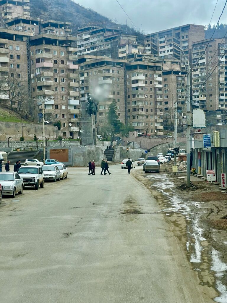
Kapan, is a real Soviet town, with row after row of simple concrete apartment blocks. Usually poorly built and even less maintained. Those who own apartments (or rent for a long term), make adjustments, like blocking up windows or closing off balconies. The blocks look shabby, but when it’s laundry day, they become colorful, when laundry flies on the lines between the apartment blocks.


A nice drive through a valley brought us to the city of Kajaran. Not as big as Kapan, but still the base of the largest open mine pit in Armenia. From here we climbed the mountains again and passed the Kajaran Pass and the Tashtun Pass at 2535mtrs, with thick layers of snow on bad slippery roads. The road passes Arevik National Park, which with all the snow was no inaccessible. The park is one of Armenia’s 4 national parks and is ons of the last remaining areas for the Caucasian Leopard. Getting closer to our final destination – Meghri – we stopped near a river and parked for the night.


Next morning we ended up pretty fast in Meghri, but were disappointed by the town. Descripted as a real nice border town and the only place in Armenia where they grow pomegranate, it had nothing of that, no charm either. It was rather small (more like a big village), had no nice shops or any tourist facilities nor did we see anything that could look like of an abundance of pomegranate gardens.

A kilometer down the road from Meghri, the road ends at the border with Iran, which is a natural border, the river Aras. Going right you go to the border post with Iran and left you follow the river and go north again back to Kapan. It would make us a nice loop in the bottom belly of Armenia. Arriving at this T-section, we were very surprised to see Russian flags and Russian soldiers, manning a checkpoint. What were the Russians doing here? They didn’t stop us when we made the left turn. However, after driving one kilometer a police car with sirenes followed us and stopped us. They asked for our passports and what we were doing and where we were going. Bottom line was, that we could not continue for security reasons. Had something to do with Azerbaijan. We could either go back the same way, or cross the river into Iran. The last one was not an option.


So back over the mountains and the two passes (which we didn’t mind, since it was such a beautiful route and now we saw it from the other side). We fueled up in Kajaran, where at a gas station we met some European Peace Monitors, who were washing there jeeps. There are about 100 European Peace Monitors in Armenia from the European Union, to keep an eye on the peace (since hostilities ceased between Armenia and Azerbijan). They explained us that the Russians are also in Armenia as peace keepers. They guard all airports and border crossings. There are about 4000 of them in Armenia. It’s a bit strange to see the EU and Russia “keeping the peace” in a small country like Armenia. The real reason is that they both want the have, get or keep influence in the country. Armenia together with Georgia forms an important transport corridor, which especially now is very important for Russia and its ally Iran.

Driving back to Kapan, we parked the truck, to do a little city tour on foot. Walking through these old Soviet mining towns is special. In one way, they are very depressing (especially for those who live there, you hardly see people smiling) and they miss a nice city centre with shops, restaurants and other things which make European cities often so nice to visit. There are convenience stores near sections of apartment blocks and there are these small moms and pops stores. Not bigger than a closet where you hardly find anything, since stuff is pilled up (often outdated things). There were also many(Off-duty) Russian soldiers walking around in the city, which made you really feel back in Soviet times. A rundown playground with a carrousel, looked like the one I saw a couple of years ago in Chernobyl (Ukraine).


Visiting some of the little shops for some supplies, we were surprised to see how kind, friendly and helpful the shop owners were. Almost as if we brought a little moment of joy into their boring daily routines or that we brought hope, that tourists would come and bring some change and money to town. I don’t know, but it was a nice experience. On the way back, we passed a little kiosk near the river, which runs through the city. It was a public dentist in this kiosk. A row of people was waiting outside (the kiosk was very small and besides the dentist, his chair and a cabinet not much else could fit). It most probably was part of the governments free health care system.


From Kapan we wanted to drive to the city of Goris, but not via the same road as we first took when driving to Kapan. We wanted to make another loop, like when we were in Meghri. A small road through a hilly region, goes up north and gets very close to the border with Azerbaijan. We passed a huge reservoir (Artsvanik Reservoir, part of the Artsvanik tailing dump, a dump site for mining waste) with heavily contaminated mining waste water. Hearing and reading about the dump and reservoir, I realized that behind all the little villages we passed in the area, there is an enormous amount of tragedy. Loss of large sections of arable land, contaminated drinking water, sick and dying cattle and huge impact on the health of the local residents. If I compare the environmental problems of Armenia with the ones in Holland, what are we in Holland actually complaining about?


The road became foggy and there were more sharp bends. According to our GoogleMaps, we would encounter a checkpoint very soon. With only a few meters of visibility, I drove slowly, not knowing what exactly to expect. Then in the fog, I saw a few soldiers with helmets and ponchos. A boom closed off the road and a little road to the right was going to a village. The soldiers where two young conscripts, who looked more like two Harry Potters, than Rambos! They were friendly and correct, but they informed us we couldn’t go straight or right. If we continued, the road would go partly through Azerbaijan (just a bit over the border). And according to them the Azeri border guards were all but friendly. Going to the right, we would get too close to the border as well. So, again we had to go back, towards were we made the turn. Which means we had to pass Tatev and the monastery again.

Driving back towards Tatev, we were following the main road, used by the trucks going south/north and north/south. It started to snow again, heavy snow combined with fog. Driving between big trailer trucks, going up and down the mountain roads, taking sharp hairpins, became a tiring way of driving. Since it was now late in the afternoon, we started to look for a camp spot, but that was not easy on a mountain with forests and snow.

It happened often with me that I see a spot at the last moment and have to make a quick turn off the road. And most of the time my observations are good, like now again. A little muddy track up a small hill in the forest, took us away from the main road and brought us after a few kilometers to a wide, flat spot, surrounded by snow covered trees.
A great quiet spot to spend the night!
Next morning, we woke up with a thick layer of fresh snow on the truck and the path was all white as well. Still we wanted to move on and slowly, with 4×4 engaged, I drove off he hill towards the main road, which was cleared from the snow. That the slippery roads could be hazardous was reminded to us, when we passed a tanker trailer, which was recovered from a valley, when it slipped of the road. The sun was slowly coming behind the clouds and the fog was almost gone. Some low hanging clouds in the valleys and between the mountains, made up for a nice panorama.


We passed the monastery of Tatev again and now the monastery was covered with snow, a complete different picture from when we passed it a few days ago. Driving down into the valley, we crossed the natural bridge and doubted if we would stop to try again the hike to the abandoned monastery. Decision was made and we stopped. Got our high rubber boots out and hiked into the valley where we crossed the small river (this time the dog was not there).


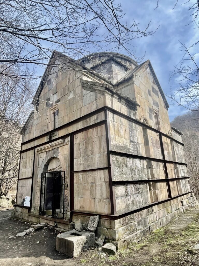
The valley was without snow (it’s much lower, so temperatures where higher). After a small hour, we reached the abandoned monastery. Partly ruins, partly still “complete”. This monastery is well hidden by the forest and not far from the small river. It has a high defensive wall, on the inside we saw many small rooms (more like little caves), where the monks used to live. The church is in tact and looking at the burned candles and a few religious pictures and crosses, it is still in use. A couple of big rooms attached or part of the defense wall, were probably the dining room, kitchen and study room.
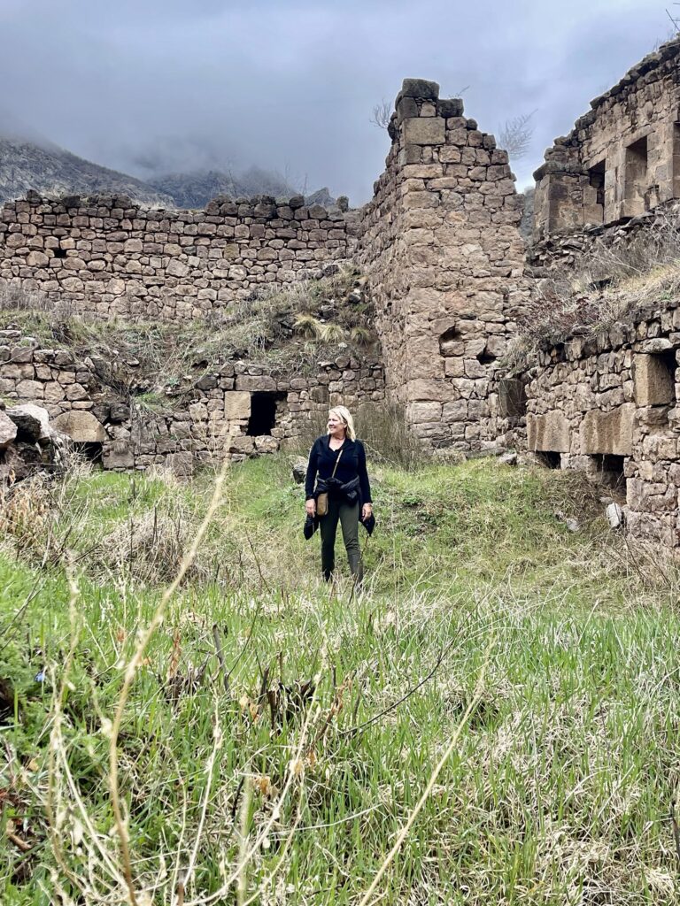
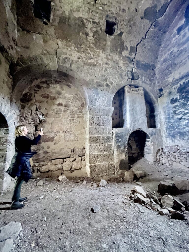

A small part of the wall where the “caves” were, looked like to be in use and we heard a voice. A man in a long black robe with a long grey beard was coming out the cave talking on his cell phone. It was the only living monk of the monastery, so it was not completely abandoned. He was the one keeping the church nice and clean and doing the prayers. He really lived a hermit life, although hikers do visit the monastery every now and then, so he is not always alone.

Back at the truck, there was this very small coffee stand. A nice guy asked us whether we wanted some local Armenian coffee or tea. After a nice hike having a coffee from such a nice guy was a great idea, and we settled down on his only two small seats. He grinded the coffee and boiled water in a pitch black coffee kettle on a small wood stove (which had seen better days). His wife had prepared a kind of pancakes or flatbread with celery leaves inside. To warm them up, he put them on the oven for a short while. And these were so nice and tasty, we loved them! Those are the little special simple moments in live we enjoy so much.


Driving out of the valley again, we passed Wings of Tatev (for a major tourist attraction, the road leading to it is extremely bad) and drove towards Goris. Not far from the Wings of Tatted there is the village of Shinuhayr. And in this very remote village we saw this huge abandoned Soviet shoe factory, which was closed in the 90’s. I couldn’t understand the logic of having such a big show factory in a remote mountain village. You need a big labor force for such a big factory. The reason why it closed is unknown to me, but a lot of people became unemployed. Small tourism related projects are developed in and around the old factory, to bring back some economic activity.


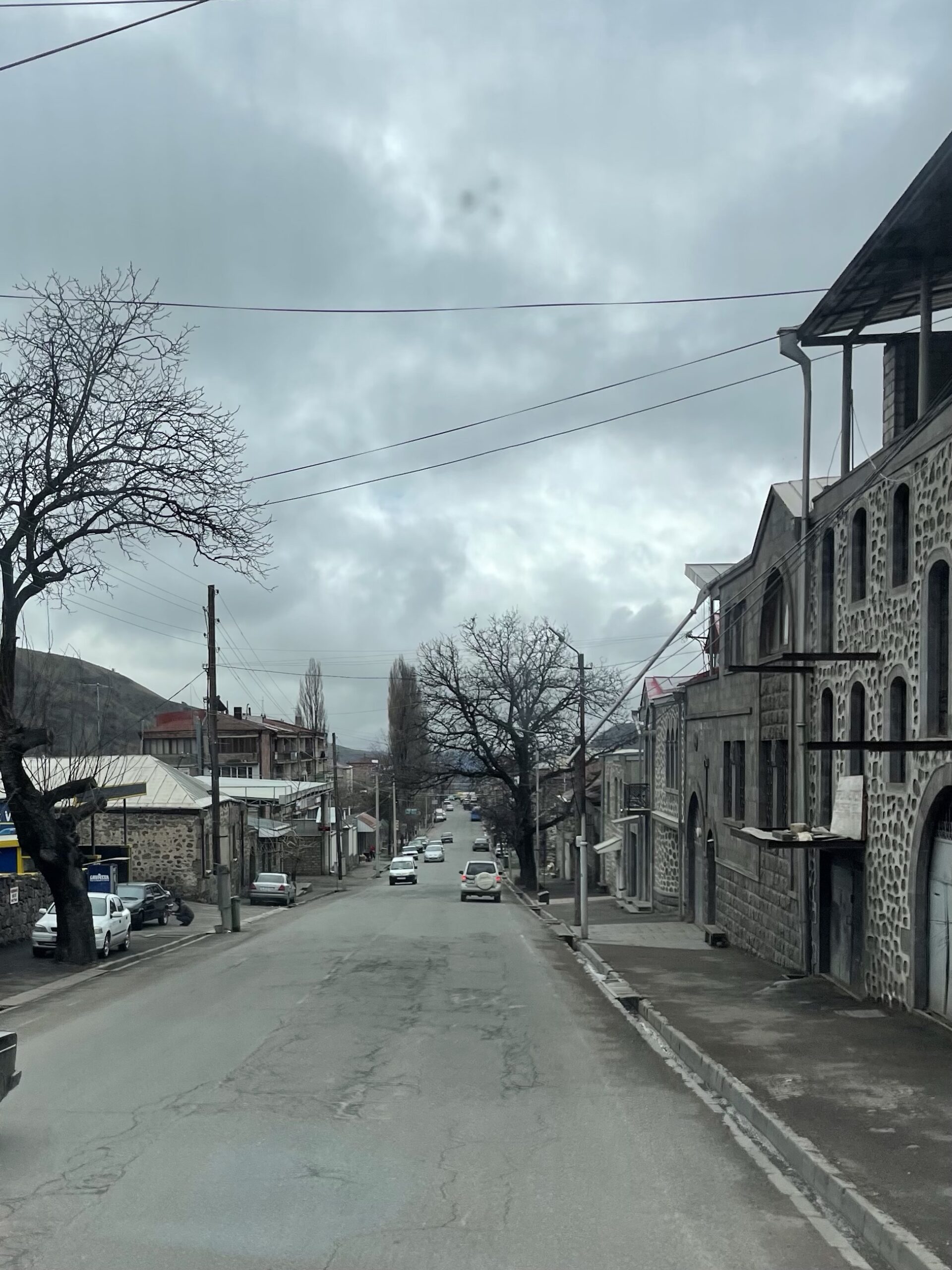
We reach Goris in the afternoon. Goris is a nicely located town in a valley not far from the border with Azerbaijan. It has a well planned road grid and numerous old buildings from the Soviet period. We drove through the town and followed the road which we actually should have come from, if we were not stopped on the other side.
During Soviet times, roads were built through the Soviet states, regardless the borders. The Soviet states were all part of one big country, the USSR. After the fall of the USSR when the Soviet states became independent countries, some roads became problematic, especially if countries are getting into war with each other. Roads which zigzag over a border (every few kilometers you are in a different country), are now full of border check-points, which makes it difficult for people who live near these kind of roads and completely depend on it.
We stopped not far from a border checkpoint for a coffee break, before heading back to town. Goris is known for its cave dwellings. Hewn in soft volcanic rocks and mountains, there are many holes, made by people, to live in. People started to make these cave dwellings from the 4th century AD.
Finding these cave dwellings was a bit of a challenge, as there are no signs whatsoever, directing visitors to the site. When we finally found it, we were surprised to see the entire site below (and up to) the cave dwellings, was a huge grave yard. And grave yards in Armenia are something else (we have seen that along the roads in Armenia). Graveyards are small memorial parks, where entire families have their own plots, so they can be buried close to each other. People spend fortunes on the graves (the total opposite of what we saw in the Arab moslim countries). The tombstones are always decorated with beautiful engraved pictures of the deceased and flowers and candles are constantly replaced, to honor the deceased.


We found a number of cave dwellings, but nothing to indicate what or when or how. There was trash and at some places graffity. Either we were on the wrong location or we were completely mislead by the information we got from the internet. We did not have the impression that the Armenians are proud of this part of their history.

Even worse, the suburb from Goris, bordering the graveyard and the cave dwellings, encroaches the area. The lower located cave dwellings are used by the people as storages rooms, garages or stables. Some have made doors and windows at the entrance or blocked the openings partly up. There was for sure no heritage protection for the cave dwellings, neither a museum, showing archeological artifacts and explanatory information.


Walking along the volcanic rock formations, we climbed all the way to the first ridge, the end of the cave dwellings. The higher we got, the more plastic garbage we found. When we reached the top of the ridge, we noticed why. The city landfill was behind the mountain were the cave dwellings were located and when the wind blows, loose garbage flies over the ridge. Great, was also not mentioned on the various tourist websites.
Continuing on the ridge we climbed to a high mountain peak, which overlooks the city. On top there is a huge Christian cross and people go there also for worship. Indeed from here the view over the city was beautiful and made up for the disappointing visit to the cave dwellings.


Not too far from Goris was a small lake or reservoir with small beaches. Nice and quiet for the night. However, a strong storm passed over the area that night and it was as if we were on a boat. The truck was shaking so much and the noise was so loud, that we had a bad night. Next day, it was still blowing hard and there were even huge waves on the small lake. And when driving, I had to work hard to control the steering of the truck.
Near the city of Sisian, we made a turn off (the wrong one), and accidentally we ended up near the Armenian version on the “Stonehenge” (which we couldn’t find on the our way down to Meghri). The site was fenced and the gate was locked. The office container at the entrance looked deserted, so we walked along the outside of the fence to see what was there to be seen.
When we were all the way to the end, a lady called as from the entrance gate, most probably a staff member. So we walked back and indeed, it was the lady for the tickets. She was in the container, but didn’t see us and we didn’t see her. She opened the gate for us and told us, that when we would be back, we could pay for the entrance tickets.
The site is called Zorats Karer and consist of a number of standing and laying big stones. A number of them have a round hole drilled through them. There is also a large tomb and several layers of stones put on top of each other. There is heavy debate between scientist about the origin, the meaning and the date of construction of this site. Some think it’s an astronomical site (based on the position of the stones and the holes within), others say it’s a burial site an again others say it was a small fortified city. All in all, it’s still open for discussion and research is ongoing.


When paying the tickets, we were invited in the container, where the ticket lady and another lady were making coffee on a small burner. The treated us on sweets, cakes and apples and of course coffee. Google translate helped with the conversation and we were shown multiple family pictures. Very nice ladies and it was really cozy in the container with all the goodies and the small electric heater (the cold wind was still blowing).

From Sisian we drove towards the spa resort town of Jermuk. Again we had to climb a snowy mountain pass, where we almost got stuck in thick mud along the road, when I thought to park for a coffee break. The mud is very slippery and I felt the truck sliding downwards in the wrong direction. Engaging 4×4, steering counterways and let the truck slide towards a hip of dirt saved the day. From there I could lower the tire pressure and got more grip to move back to the main road. But the amount of mud glued against the truck and my shoes (went out to check the situation), was really bad.

From the main road we took the turn to Jermuk, which is located at a height of around 3000mtrs. It started snowing again and the higher we got, the more snow we saw. Along the road up to a long plateau, we saw big rocks which fell down not too long ago. Reminder that not only slippery snow, but also falling rocks, are causing a lof of danger on the Armenian roads.

Arriving in Jermuk it was now snowing a lot and besides the roads and some parkings, everything was covered with a thick layer of snow. Parking the truck somewhere was not really an option, neither driving back. So we decided to look for a nice hotel that night. Jermuk was known during the Soviet times for being a health resort area and most of the hotels are from that period. Some have been upgraded and a couple of new ones have been built in the meantime as well.

The Grand Resort was our choice, it had at least a big open parking and the occupancy was minimal at this time. To get a room and use the several spa facilities, we had to do a health-check at the in-house doctor.
A Russian looking female doctor, with bright lipstick, eyes like a falcon and a Russian style uniform, took our blood pressure and asked some questions. She filled out a form for each of us and gave it to the lady in charge of the spa center. The lady explained what was all available and showed us around. We both booked for a massage at the end of the afternoon and after changing in our room, we went back to the spa to go in the jacuzzi and after that the sauna. Really nice for a change after 2 months in the truck. The large bucket with ice cold mineral water, which hangs on a wall and can be pulled down with a rope, really freshed us up!


The diner was really Armenian style. Totally not a form of fine dining, but a lot and bulky. With the salad, the chef probably wanted to safe her knives, because the tomatoes were just cut in half, the cucumber in slices of more then a centimeter. The meat was grilled, but looked like charcoal and cut by a blind butcher. Anyway, we go for the experience (but it made me appreciate Marja’s kitchen evenmore). There were a few Armenian families with children and most of the people were dressed as if they were staying at a camp site, and not at this fancy hotel. Nothing wrong with that, but it showed us how descent, simple and no nonsense the Armenians are. The old communist mindset is probably still there somewhere.
Next morning we had an Armenian style breakfast, and we went back to the spa area to experience some more of the fun they offered there. Oh yes, the massages yesterday, they were very interesting. I had a bulky Russian lady (not the pornstar I had in mind) and Marja was massaged by a Russian Hulk (yes this guy was very big and I think both he and my lady used to work for the KGB in the interrogation room, but that was our conclusion after the massage). Where I had most probably the softer of the “massage package”, Marja was tortured! Even her ears were stretched out (one ear is now bigger then the other). If both of them had asked us if we had killed JF Kennedy, we would have admitted it!
Anyways, in the morning in the spa we were treated with a mineral bath. The mineral water is what Jermuk made it a resort town. The mineral has a healing effect for people with skin problems but it is also beneficial for other health related issues. The mineral bath was followed by a foot reflex bath in mineral water. Well that’s another torture exercise! Walking on river rocks in a bath of mineral water, in circles. That really hurts if you don’t have strong feet (or if you are not used to walk bare feet all the time). Luckily, it were not glowing coals that we had to walk on, it could always be worse.
Marja got a parafine treatment for her hands, and after that the last “treatment” was sitting in the “salt-room” for a while. The salt room is a room with a layer of natural salt from the caves on the floor and salt air is being blown through the room. In the Salt Room we met a nice family and an Armenian lady, who lives in The Netherland for many years and she spoke perfectly Dutch. So this was a nice way to close off our “spa adventure” and escape the snow. Packing up our stuff we went back to our snow covered truck (during the night the snow continued to fall) and drove back towards lake Sevan. We drove through magical snow covered Jermuk and stopped at a small frozen lake, where there was an old little chapel. A beautiful scenery.


In stead of going straight in to the direction of the Selim pass, we wanted to make another loop again, this time around Mount Tek. Unfortunately after reaching the last village high in the mountains (which looked almost deserted), the snow plowing crews had stopped. From the last village the road was still covered with a thick layer of snow, so we had to go back to our original route.


Crossing the Selim Pass, we saw many snow plowing crews cleaning the road again. Also here a lot of snow had fallen. From Martuni, we went right and followed the road along the shores of Lake Sevan, a part we had not driven yet. Along the the southern part of Lake Sevan, part of the land and the water is a Nature Reserve, so you won’t see any construction. Here and there are landing areas for the small boats of the fishermen. It’s also a popular area in the summer for mostly local tourism, when people escape the summer heat. Unfortunately also here, we saw a lot of garbage left behind by the day trippers.


Under a large pine tree, we found a nice area to park the truck. It was still cold and windy but the area was nice for a little hike. The view over the lake and the mountains was amazing again.

Next morning when we were almost ready to leave, a big Armenian man in a camouflage outfit, driving a black Lada, came to us. First thought of course, was that some official came to check us out again, but no. This guy was not talking about “passports” but “Riba”. No idea what he was talking about, he asked me to come to his car. So now I thought he had a problem with his car. No, wrong again, he opened the back door, he had boxes with smoked trout from the lake. In the trunk he showed me fresh caught trout. He was selling fish! The smoked trout smelled super nice, so I bought a couple of them (Sevan trout is a rare species and therefor a delicacy).

Staying close to the shore, we bypassed the main road and followed a road on an old dyke, going along agricultural fields on the right and the Nature Reserve. The road was in a bad condition, but it was worth it, the scenery. We saw many birds of prey, hunting for little mice. A small turn-off brought us to a pristine lakeside beach, where we spent a good part of the morning and where we made some drone footage.

Continuing the beautiful road along the lake, we passed nice villages and abandoned (looking) railway stations. A rail track follows this side of the lake from Yeravan all the way to Sotk (a large gold mine). Cargo trains run here all year round and passenger trains only in the summer, to bring tourists from the capital area to the sunny shores of Lake Sevan. The main station for the sun baders is in Shorza. The entire rail network is owned and operated by Russian Railsways!


From where the Nature Reserve stops, you see many vacation homes, parks and restaurant and other tourist facilities. It all looked very deserted, since the season didn’t start yet. We also saw many unfinished structures, which looked like places gone bankrupt due to the economic problems Armenia had or has because of the war. One place looked very new and very European (Ibiza style). This looked hopeful, as maybe young entrepreneurs want to move forward.

Exploring always the road a little further or higher up, we left the lake side and drove land inwards. The idea was to (again) drive close along the Azerbaijan border to the village of Berd. The Chambarak pass was an easy drive for us this time, since it was not so high and not so much snow. A bit after the pass we took another turn, on a road hardly used, badly maintained and full of snow. It was slippery and narrow, but beautiful again. Small avalanches had taken place, covering the road with soft snow, but we could drive through it. At a certain point you could clearly see the Azerbaijan side, the closest we could get, without being stopped. Nobody would expect tourist driving here this time of the year, due to the amount of snow and………..after a while, there was really too much snow on the road caused by a big avalanche. Now we had to turn back. Turning around on a small slippery road is not easy. The truck slides and I have a big turning circle. With my back bumper I could push the truck backwards in the snow on the side of the road, to make more space. Marja checked that I didn’t go too close to the edge of the road. Finally the truck was around and we could drive back. At that time somebody was shouting higher up the mountain and was running towards us. I had no idea where he came from and what he wanted. Was he an Azeri or Armenian border guard or a civilian from the isolated village high up the mountain? I didn’t wait for an answer and we drove off. We weren’t suppose to be there anyway.

Driving carefully back over the slippery road, we reached the main road, which let to a national park. The main road we followed goes straight through the park and because of all the villages, little towns, hotels, restaurants and other commercial buildings, we did not have the impression that it was really a national park as we envisioned. The park is spread over a number of mountains and valleys, so we don’t know if behind the habitation there was still unspoiled nature left. A sign on the road mentioned something about a visitors centre, so we took a small road up the mountain. After a short drive we passed an idillic little village. The road continued towards another village (the end of the road) where also the visitors center was located.
We realized the park was not a Nature Reserve but more a cultural reserve, where people still live in a more or less traditional way in some kind of harmony with nature. They cultivate their small plots in a sustainable way, have some life stock and live a simple life. Modern roads and construction is not allowed as well as big scale farming.
While walking in the last village (Kalavan) a vehicle stopped and a young American man approached us. He was living in the village and had some kind of retreat center. He invited us to come to his center, which was also his house to have a coffee. He had extensively travelled the world and had written and published a number of interesting books. A couple of years ago he decided to settle down and did that in Armenia in this little far away village. He bought a run down old house and started to renovate it. Overtime, he decided to utilize is experiences, by helping the local population, by teaching them English, music and entrepreneurial skills. He also invites volunteers from all over, to assist him with his renovation project and his villages projects. In the meantime, the volunteers can enjoy staying at the center, discuss things of life and relax within the area of the park. It was an unexpected surprise to meet somebody like Gregory, in such a hidden place, with a very interesting life story and an even more interesting mission.
The area of the village and the park didn’t offer a good location to camp for the night, so we got back on the main road and found a place on a hill overlooking the valley with the hotels and the restaurants.
Next morning we did a hike in the park where two old abandoned monasteries were located. A steep path brought us to the first monastery (Jughtakvank).The church of the monastery was still in use, but the top of the dome was gone and snow was covering the floor in front of the altar. The building was in such unstable state, that it was reinforced around with steel. From here we took the wrong way and started to climb an even more steep path. The path was muddy, with water streams and snow on the side. It was a difficult walk. But due to the fact we were now off the track, we started to see wild life, like wild boar and some deer, running away from us.

Realizing that we took the wrong path we walked back to the monastery and found the right path again, leading us to the next monastery (Matosavank), which was more like a ruin. Tomb stones were scattered around the monastery, reminding us of the hard working monks who spent a large part of their life here in isolation until death.


We were happy that we did the hike and realized that behind all the houses and buildings along the main road in the park, there was still a lot of untouched forests with wild life. Large old trees survived the timber industry from the Soviet times and small creeks with cristal clear water were flowing through small valleys.
Via the city of Dilijan we were now driving towards the border with Georgie. Unexpectedly we drove to one of the nicest valleys of Georgie, the Debed Canyon. The Debed canyon is also the lowest area of Armenia and therefor, spring was already well visible and the temperature was warmer. We stopped at a very nice and modern visitors center with a European style coffee shop. It was part of the COAF (Children Of Armenia Fund), a Foundation, mainly supported by foreign donors, that helps develop rural areas in Armenia, through healthcare, education and social and economical development.
The Debed Canyon is a developing area, focussed on hiking tourism. The number of small hotels and guest houses is growing as well as restaurants and activities. Will driving through the the canyon we saw huge rusty abandoned industrial complexes. We couldn’t understand why industry was developed during the Soviet period in this beautiful narrow valley. It was later explained to us that in the mountains around the valley there were mines, which was the reason why the factories were placed there. The closure of these factories caused a lot of unemployment. Tourism it now becoming the main new industry and the hope for those who lost their jobs, to make a living again.
Near the end of the valley, we turned up to the mountain again to go to the village of Haghartsin. Via I-Overlander, we found another campsite in Armenia (after 3G’s Camp of Sandra) and we wanted to try that as well on our last night in Armenia.
On arrival at the gate, the young owner, Martin, came to inform us that he was still closed until 1st of May and that most of his facilities where not operational yet. We told him that we are 100% self sufficient and only needed a place to park for the night. That changed his mind and we were allowed to get in and park the truck. We had an interesting conversation with him about the area, the factories, politics and himself.
The camping is quite basic, but situated on top of a cliff with a great view. There is a kitchen building, some showers and toilets and campers can make campfires. Martin likes his trees and he has planted numerous varieties of fruit trees throughout the campsite.


The campsite is on the outskirt of Haghartsin, which is a nice sleepy mountain village. Several hiking trails cross in the center of the village, where – again – a beautiful large monastery is located as well as a small hotel and a few shops. We hiked all the way up through the village and visited the monastery. A very enthusiastic caretaker, led us through the church part of the monastery and explained a number of things. The floor of the church is one big graveyard. You walk over the tombstones. Three Armenian kings are buried in the church, showing the importance of the monastery. Old medieval frescos can be seen on the walls and columns in the church, which are restored by Italian specialists.


We bought some fruit in one of the stores and hiked back to the truck for coffee. Nearby the camp there were ruins on top of a narrow cliff, of an ancient city castle. So we did another hike to that one as well. Along the way, we saw a big muscular Armenian gentleman busy directing workers near the path towards the ruin. He came to us and explained what he was doing. Cottages and a restaurant are his plan to build. Signs of a changing environment, also in this village. (The former mayor of the nearby town, allocated one of the nicer plots to himself and built a nice hotel already. Development and corruption go often hand in hand).


After the last hike, we jumped in the truck, did a last fuel up and drove towards the border. It was time to say goodbye to Armenia.