From the isolated West Fjords, we returned to mainland Iceland after we left our camp spot at the waterfall. The area we now entered was closer to Reykjavik and with better roads. We drove along a coastline dotted with many small rocky islands, a labyrinth clustered in the sea. A small fishing boat lay abandoned on the shore of one of these islands, reminder of the perils fishermen encounter in this part of the world.


This islands, some having small patches of green, used to have small isolated farms, but not anymore. A small church under renovation was the only place, where the farming families of these islands met, for services, funerals and weddings. An old man with his daughter, was tending to the grave of his mother who died on one of these farms when he was 9 years old, when they lived there. A testimony of the attachment people have with their relatives and the soil they have lived on for so long.

The peninsula of Snaefellsness was the last peninsula we would visit before heading back into the highlands. This peninsula, an hour drive from Reykjavik, is very touristic. It has the oldest church made of concrete in the world (wonder how true that is), and a national park centered around a large snow covered volcano, where a paved road leads visitors through the lava fields. A re-discovered fresh water well covered with whale bones is one of the highlights in the park. An unpaved loop from the main paved road, invited many unprepared tourists with their rental cars, to discover how it is to drive on rocks and lava stones. This loop leads at the end to two lighthouses, left and right, and this is considered the closest point to Greenland. Half way the loop you can do a hike towards three small dormant (recent) volcanos, which can give you a nice idea on how volcanos are born. Here we had to put some effort into climbing the volcanos. A dormant volcano along the main road was easier to access for the comfort tourist. A well constructed steel step walkway, made a visit to this crater for almost everybody accessible.


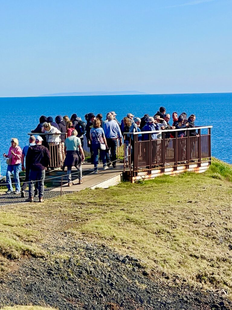
Further along the road, there is a well known cliff walk, where people can see the many breeding birds. We were surprised by the thousands of tourists, dropped off by many buses or rental cars, walking around in a special village built to cater for these tourists. There are restaurants, souvenir shops, hotels, all because people want to see and walk the cliffs. What a difference with the two highest cliffs we saw in the West Fjords!

Near the end of the peninsula we stopped at a small monument near the ruïne of an old farm. It was dedicated to Gudridur Porbjarnardottir, the first white woman who entered the American continent and the first white woman to give birth on the American continent around the year 1000 AD. She was a well traveled lady considering the time she lived in, crossing the ocean multiple times and she even visited Rome. She was her time far ahead.

Back into the highlands, away from the crowds, along a river, we found the solitude we love so much. Our night camp spot was determined.

The next day we drove through a valley of volcanos and on both sides the two largest ice caps of Iceland. We witnessed first a small drag race between two tourist vehicles, whereby one wanted to overtake the other one, but that other one did not give space for the other to pass. Some people take their home stress with them on holiday. Its a shame.

Down the road we saw an example what such driving behavior on small unpaved roads could lead to.

The road we followed was also a short cut to an important tourist hub from where people could do excursions and tours. One is the ice tunnel on a nearby glacier, which you can reach with one of these special designed ice buses (which I mentioned in a previous chapter). Or visit fancy hot springs in a spa like environment. We passed all that and continued on a challenging F-road. The idea was to make a circle around the Hofsjokull icecap via one of the most difficult tracks to drive (with a truck). We were advised not to do it, but we are not the type of people to give up that easy. It was an advise only.
But after a few hundred meters into this track, we realized that it would be a very long and tough drive. The small rivers and streams went through deep ditches, the hills and flat lands were densely covered with big bolders, and the track was winding through this rocky fields in such a way, that by driving over the bolders, sometimes we were hitting parts under the truck. A local guy with an old 4×4 Chevrolet ambulance turned campervan passed us with relative ease (his van was shorter and could navigate easier through the bolders). After driving for about an hour and only covering 5km (we still had 50km more to go), we convinced ourselves, that it was close to impossible for the truck to pass this track. Indeed. We drove back to make a detour of about 200km to reach the point where the track would have ended.


The detour went through a huge marsh area with hundreds of lakes, and was a single lane narrow gravel road, built on a dyke. It’s a popular area for trout fishing. Along the way there are some shelters, but nobody lives in this remote area. Reaching the northern tip of the detour, we were back on the N1, but not for long, because now we had to go down south again. This road went through a long green valley full of farms and rich in history, due to the Viking settlements with all their stories, which were told on small bill boards along the road.
The road stopped at the end of the valley, at the gate of a farm. However, the road (now a track) was accessible for public use, so we continued on this track. Again a track with no other traffic, beautiful landscape and half way a nice camp spot with a view on a nearby lake.

Back on a main gravel road, we met a nice guy who explained he is a well known sports fisherman from Germany. His 4×4 pick-up with an attached camper unit, was covered with advertising for fishing gear, showing he for sure had some followers on his social media sites. Iceland is a great destination for sports fishermen as well. Showing us the huge trouts he already caught in Iceland, I understood why. Robin Hook, and a very friendly guy!

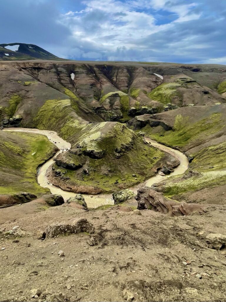
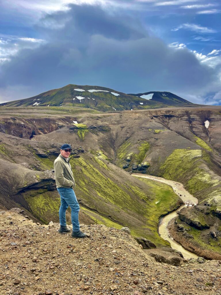
Traveling unprepared for what to expect when being on the road, could lead to missing interesting places. But it could also add to the surprise factor and an increase in adrenaline when encountering these places unexpectedly. And that is how we travel. Not too prepared, but open for anything new. And so, we had such moment again when we first entered a small area of mud volcanos at Hveravellir next to a campsite with a small hot water pool. And later, entering an amazing gorge area, where a big resort was built in the middle of nowhere, including a large campsite. To our additional surprise, there was another (German) Bliss Zetros truck parked near the resort. We stopped by the Zetros, knocked on the door, but, unfortunately, nobody home.


Driving away from the resort, we followed a steep mountain road, which went to the top of the canyon and provided amazing views over the area. But the biggest surprise was this collection of mud-volcanos tucked between the glaciers and show casing an amazing variation of colors on their slopes. Steep slippery paths, with here and there improvised stepladders and bridges, allowing the visitors to walk from one volcano to the other, through thick sulfate clouds.

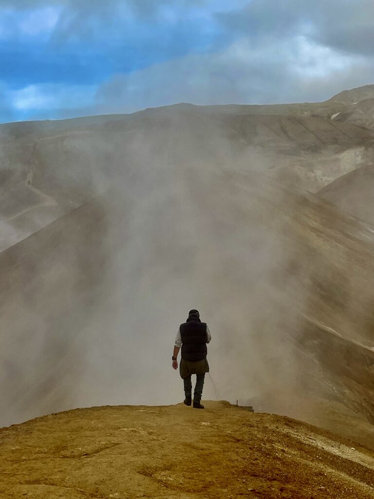

It was a surreal site, like being on a far away uninhabitable planet or like going back millions or billions of years, when planet Earth was just born. The mixture of the clouds of chemical gases, the sound of the forceful blows of hot smelly water from the deep parts of the Earth, the rainbow like colors from different minerals on the slopes of the surrounding hills, and all that surrounded by ice, snow and rocks, is a beautiful spectacle by itself!

It was also the end of a road, which we thought would continue, so we had to look for an alternative to continue our way south. A track, dedicated to the 4×4 club of Iceland, was the first option we found and we tried. But if it is an 4×4 club dedicated road, it is a challenging road, mainly or specially designed for 4×4 super jeeps, so yeah, we got almost stuck again and had the go back in the direction of the resort to find another road or track.
The main gravel road from the south to the resort is what we had to follow, but this one was busy with tourist vehicles of which many seemed to be in a hurry. Although not many side tracks to find a campspot for that night, again we managed, driving down, out of sight from the main gravel road, another nice spot along a river.

Back on the main gravel road the next morning, we finally found an alternative (although a big warning sign was telling people, that this road was going through an isolated area and help in case of emergencies could be very limited). The road was a former service road for the high tension power lines. A local lady driving a 4×4 pick-up truck, advised us not to go there, but we still went. We had asked her whether she thought it would be too difficult for the truck, or too dangerous. When she said “difficult”, we decided still to go. The area is called the Hrunama Naafrettur Wilderness and is absolutely beautiful with green rolling hills, small canyons and little rivers. Indeed, there were some deep river crossings and sharp hairpins curves to tackle, but we managed as usual.


The road ended at the highest one drop waterfall of Iceland. We saw earlier in the trip the biggest waterfall of Iceland (which is also one of the main tourist attractions of Iceland and every visitor to Iceland has it on his/her list to see it. Again, there we found too many people, packed parking lot, souvenir shops and restaurants. Too touristic for us. But now we found this one. Only a handful of people, no tourist infrastructure, just a beautiful gorge, where a river splits itself into two big waterfalls. For us it was much more beautiful than the biggest one I just described.


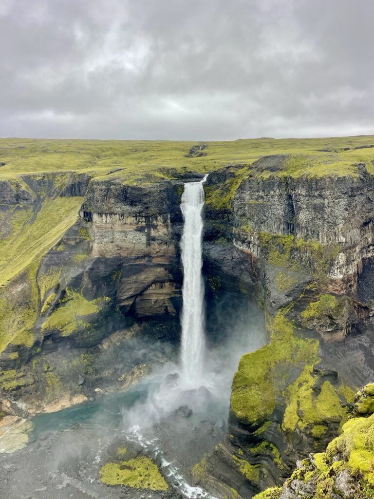

It was really one of the more spectacular sites we have seen in Iceland. Later we would fly over it again, to even more appreciate the beauty of it.

The day after we saw the German Bliss Zetros, we got contacted by Bliss, saying that the owner would like to get in contact with us. We had no problem with that. And so the same day we corresponded by WhatsApp and agreed that we would try to meet at Landsmannalaugar (another top tourist location in Iceland). So after visiting the last waterfall, we headed that way. Landsmannalaugar is an very popular campsite in the middle of the Fjallabak Nature Reserve. The site is between a huge wall of a former lava flow and a river delta. The park has exceptional beautiful and colorful rock formations and is popular for its hiking trails. Besides that, along the lava wall flows hot water, making it popular for those who seek natural hot springs as well.

The ride through the park winds through a lava field, crosses some small rivers and offers spectacular views on dormant volcanos.
We arrived late in the afternoon and Sebastian (the German owner of the other Zetros truck) was definitely expecting us, he had reserved some space next to his truck for us. He was very welcoming and happy to meet other Zetros fans! After a short introduction, he invited us for dinner in his truck, which we happily accepted. In his truck we met his girl friend Helena, who had prepared a nice diner. We spent a great night in their truck, exchanging nice stories and experiences. It was really fun!
The next day we were all supposed to explore the park, but now it was pouring rain. So instead we all spent time inside our trucks, while communicating with WhatsApp via our Starlink dishes. (While standing two meters apart from each other). End of the day, we all got fed up and in the rain we jumped in the hot pool bringing a nice bottle of bubbles. And we were not alone, the whole camp was tired of the ongoing rain and the hot pool was a nice escape for all.

While in the hot pool, we saw a convoy of white trucks arriving. These were the Bliss rental trucks used for tours in Iceland and some other countries. These tours are organized by Overland Travel. Potential customers for Bliss or people who just want to try an expedition truck, go on a guided and organized tour, with a guide and technicians (with a recovery truck) and discover both the area they are traveling through and find out if the Bliss unit specifically is what they like. This time the group consisted of Chinese travelers. China is a growing market for Bliss.

At night we invited Sebastian and Helena for a pancake night. Marja made a huge pile of pancakes, as we also expected the two Dutch guys from the Bliss convoy. But they had to stay with their guests. We understood, so again a nice evening of story telling, jokes and exchanging ideas and experiences with Sebastian and Helena.

The next day it was still pouring rain. The rivers in the park were swollen to the max now, and it became more difficult to drive, especially for the smaller cars. Rocks were also falling down here and there, and we even saw cars stranded in the middle of rivers. Later we were told that the park was closed for all traffic, the camp became isolated. We had left early morning and were able to manoeuver through the rivers and flooded roads. We passed the last beautiful area of Landsmannalaugar, with huge lava fields covered with bright green moss (which you only find on certain types of lava) and a rainbow which completed our visit to Landsmannalaugar. We were not able to see its full beauty because of the rain, but met instead some great friends with whom we had a really good time. So we left feeling happy, despite of all the rain!


Driving south, away from the park, the weather cleared up and the sun started to shine. Sebastian had suggested us to visit the Lava museum, which was more or less on our route. An interactive exhibition, which explains a lot about volcanos, the type of eruptions and lavas, earthquakes and the situation in Iceland in regards to these volcanos and earthquakes. It was indeed an interesting museum. After visiting all such lava fields and dormant volcanos, it’s very interesting to learn the details, the origin, the causes and the effects of the natural phenomenons. To our surprise, when leaving the museum, we met Sebastian and Helena in the coffee shop of the museum, so we spent some time together again. The museum offered good coffee and nice cakes.
We said goodbye and we went further south towards the last peninsula. A random official, but free campsite along the coast near some run down homes and car wrecks, was our only choice to camp for the night. Luckily we stopped in time, because by late night, the camp was more than full (the word “free” is appealing of course), with small rental van campers. The budget travelers had arrived!

Next morning we entered an area, where until the middle of August there was a lot of volcanic activity. Signs along the road still warn people of the danger. Commercial as Iceland is, paid parkings (the parking fee is actually a visitors fee) are placed around the volcanic area, from where hikes are mapped out. Since the volcano came to rest by now, we decided not to do any of these hikes.


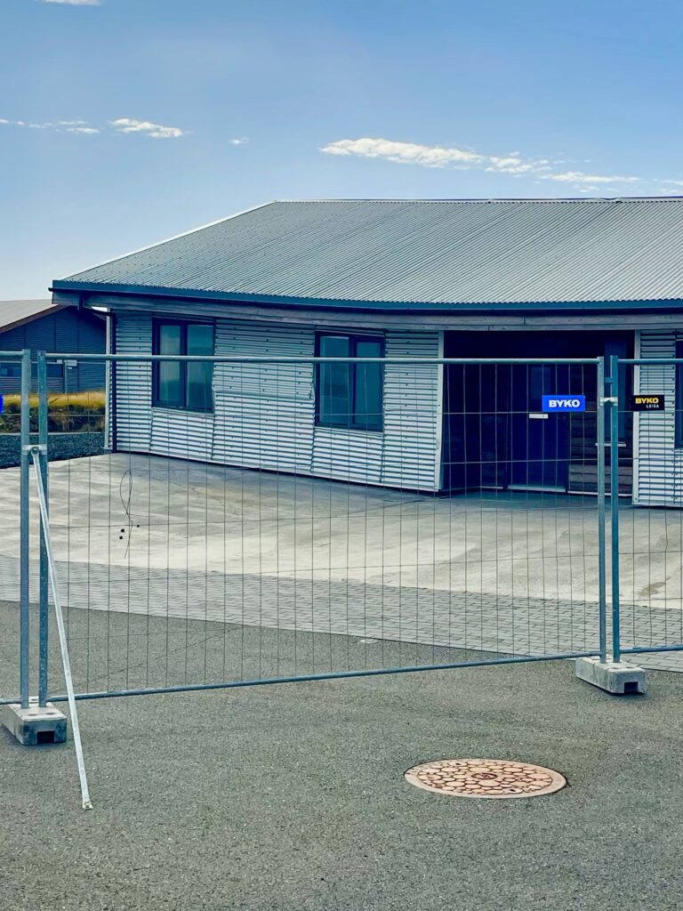
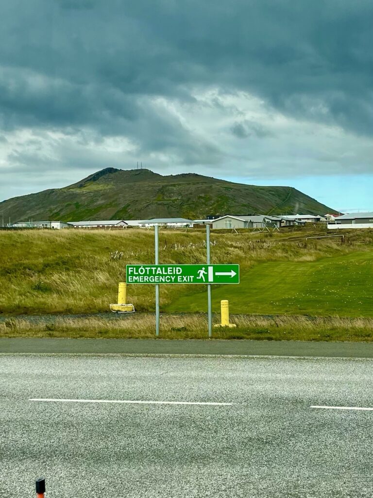
We moved down the road and reached the city of Grindavik. This city of 3000 inhabitants was completely and hastily evacuated in 2024, after a series of eruptions, earthquakes and lava flows entering the outskirts of the city. Entering the city now was a bit eery. Clean streets, no cars, empty houses and stores. Then you see houses with security fences around it. You see big cracks in the walls, side walks and drive ways. Some houses are out of position, by being lifted up, due to ruptures in the ground. Huge tunnels of hot lava flowed under the city, causing two long ruptures through the city. New big houses and houses that were under construction were left abandoned and roads were temporarily fixed or completely relocated to allow traffic to continue. The situation became so unstable (and still is), that the government made the decision, to permanently evacuate the city and buying the houses from the inhabitants.


An open air photo exhibition on a parking lot gives visitors a realistic impression from the dramatic events, which unfolded during the evacuation. It also shows that life in Iceland is strongly connected with volcanos, as almost yearly, there is some volcanic activity, especially in the south, where most of the Icelanders live. We feel a certain resignation in the Icelandic people, they realize very well the unpredictability of the nature around them, and know they just have to live with it. As it is of course impossible to change that. The people, but more importantly the government of Iceland, made many preparations and has emergency plans in place for situations caused by volcanic activity, earth quakes or mud/snow avalanches.


The Reykjanes peninsula is the most active volcanic area of Iceland. Besides volcanos, there are mud and hot water springs. There is so much hot water (boiling hot), that Iceland is harvesting this as a natural resource, for their power plants using geothermal energy. 100% of Iceland’s electricity is renewable and Reykjavik and surroundings are heated with the same geothermal energy. Reykjavik is the only capital city in the world run on net-zero energy.

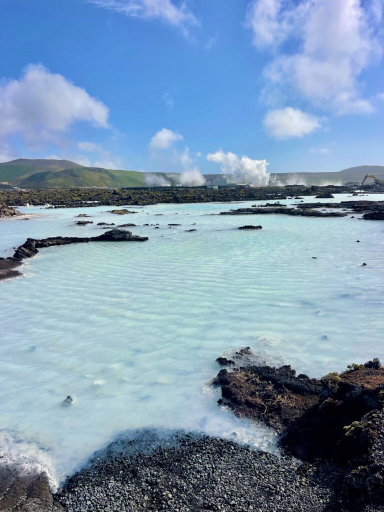
Still, with all this seismic activity, 65% of the total population of Iceland, lives near that area in Reykjavik and its surroundings. Also the top tourist attraction is right in the center of seismic activity, the famous Blue Lagoon. In 2024, the last eruption caused an enormous lava flow, threatening the Blue Lagoon lagoon, the large geothermal power plant, same like the town of Grindavik.
The threat of losing a mayor power and heating supply facility for the Reykjavik area and the money making Blue Lagoon, caused great concern for the Icelandic government. A plan was drafted and eventually activated, to build huge dams around the town, power plant and the Blue Lagoon, in order to guide the lava flow away from these sensitive areas. When we were there, large excavators and dump trucks were still busy removing lava rock and building the dam near the Blue Lagoon.
Advertised as a unique and tranquil lagoon, with water so blue, your eyes are almost hurting. The water itself is actually not blue, but the mineral covered bottom of the lagoon makes the water look bright blue. The lagoon is fed by hot water from a large spring, which first goes through the geothermal power plant (its over 100 degree Celcius), before reaching the area, where people can swim. By the time it reaches that area, the water has a comfortable temperature. The lagoon is not one single body of water. There is a number of small pools, not in use as baths, but still in original state. Then there is the “cultivated” one, with a huge poolhouse. You pay an entrance fee, get a bathrobe and then you can swim for a while. There is a bar in the pool, where you can buy drinks. The poolhouse has a restaurant, coffee- and souvenirshop. Thousands of people come here daily and it’s more like a big regular open air public pool than a romantic far away, cozy natural hot pool. With the average temperature close to celmonella’s favorite and no filtering system, we were not eager to join the crowd in the Blue Lagoon. Although the few original parts of the Blue Lagoon, hidden between piles of lava rocks, were nice to see due to their contrasting blue color, we were a bit disillusioned with the overal Blue Lagoon experience.


The last part of the Reykjanes peninsula, lead us along the new airport, which is located approximately 45 minutes from Reykjavik. We checked out how the parking situation was, this for when we will be going to Greenland. The airport has it’s name from the town of Keflavik. The town is known under the Icelanders as the “problem” city, were many immigrants and asylum seekers live and where the first signs of a decline in safety and security in Iceland are said to be visible.
Beyond the airport, we drove along the coast and reached a small lighthouse on a rocky outcrop. The area is well known under bird watchers, since during spring and summer millions of migrating birds rest and feed near the lighthouse. A police car parked next to us, and two female officers disembarked. They didn’t come for us. They found a young drug user hiding between the rocks. Don’t know if he needed help or was on the run, however, it showed that also Iceland cannot escape the problems we are facing in today’s world.


We made a small stop in an area, where a small metal pedestrian bridge (Leif the Lucky Bridge) was placed over a sand filled canyon. It was made to show visitors, that the canyon was the growing gab between the European continent and the American continent. These two tectonic plates are drifting away from each other (which has been an ongoing process for millions of years). Iceland is therefore placed on two continents, since the canyon goes right through the country. It also means that Iceland is growing bigger, but very slowly.


The last stop and camp in the wild we made, was on the other side of the Reykjanes peninsula, on the most south eastern tip. A wonderful location, not far from sulfur hot (mud) springs. Another strategical positioned lighthouse overlooked a high free standing cliff


We parked the truck in the middle of a big wide open field. Other visitors came and parked around us and some came chatting with us. Near the edge of the field, where there was a dramatic drop off klif into the ocean, a large bronze statute was placed. It is an enlarged version of the Great Auk. A large flightless sea bird, which became instinct in 1844 in Iceland (although a last individual was seen in 1852). Because the Great Auk was big and clumsy on land, it was an easy prey for humans. Besides a food source, the down was highly valued and for the Native Indians it was also an important cultural symbol. The statue stands as a monument for a bird species, which survived for more than half a million years. The monument is there to remind people, that, besides the Great Auk, more species went extinct overtime, and others are at this moment on the brink of extinction.


Another obvious item close to our parking spot was based on two rusty key-boards, fixed in concrete. These are the so called “Volcano Man Keyboards”. These keyboard were used in the Netflix series ”Volcano Man”.

The high, single standing, almost square pillar klif nearby our truck, gave the whole area a unique appearance. Although prohibited to climb to the top, due to an increased risk of falling rocks (erosion near the coast is strong), we couldn’t resist to get to the top and enjoyed the views from there. Walking down the cliff, huge pebble stones littered the beach area below the cliff. Normally pebble stones are less than the size of a hand, but these were huge. A process of smoothing big bolders into nice round stones, is a process which takes hundreds of thousands of years.


Time to finally drive to Reykjavik, the capital of Iceland. We drove via the last pieces of wilderness on the Reykjanes peninsula. Entering the outskirts of Reykjavik, we entered a different Iceland. Besides the smaller towns of Akureyri and Isafjordur, Reykjavik is really the big town of Iceland. An extensive road network with multi lane highways, some high rises and many suburbs. In fact, there is Reykjavik, and there is the rest of Iceland.
We had agreed with Sebastian and Helena, to meet again in Reykjavik on the only camping in town, the Eco-camp. A very large, well equipped and nicely located camping, where we would park the trucks next to each other. We arrived first and got a good spot and not long after, Sebastian arrived. Was nice to see each other and we celebrated that with some drinks and snacks in the camper. In the evening we took a taxi and went to the old town of Reykjavik, where Sebastian had booked a nice restaurant (The Apotek). Was nice to go a good restaurant after being in the camper for so many weeks.


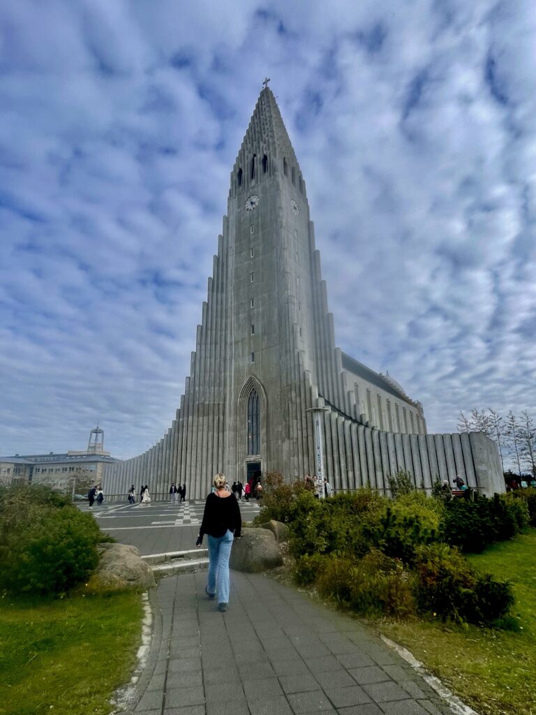
Reykjavik has a nice small old town, with restaurants, some bars, shops and historic buildings. Reykjavik is also popular by the cruise tourists. A long street, packed with street food, fast food restaurants and souvenir shops, leads to the famous modern Hallgrimskirkja. The second highest building in Iceland and the largest church in Iceland. Since we were in a big town again, we got our bicycles out of the box. A long cornice leads from the ferry terminal along the coast towards the old town, where you also pass the large, modern opera building first. It’s here where you see the sky-line of Reykjavik (some higher office and apartment buildings, but not like other big cities in the world). An old shipyard, on the doorsteps of a hotel and apartment building, was a bit out of place, but showed how fast Reykjavik has grown over the last couple of years.


We biked the next day again through Reykjavik and revisited the same restaurant, but just to have coffee and to enjoy the best pastries in town.

A day before we would leave for Greenland, Jon, our Icelandic friend (the pilot who helped us to find a new tire), invited us to fly with a small plane over a part of Iceland. That was a great invitation we had gladly accepted. Jon picked us up from the campsite and we drove to the former international airport of Iceland, the Reykjavik airport. This airport is now only in use for domestic flights (including helicopter flights) and by the Aero Club of Reykjavik.
Jon first proudly showed his hobby plane, a Super Cub, a short take-off and landing two-seater, which he often uses to fly to remote places in Iceland. Then we went to the hangar of the Aero Club, where the Cesna 4 seater single engine plane was parked. After a short tour, we opened the large hangar door and pushed the plane out. We boarded the plane and drove to a tanker truck, where we had to fuel up the plane.


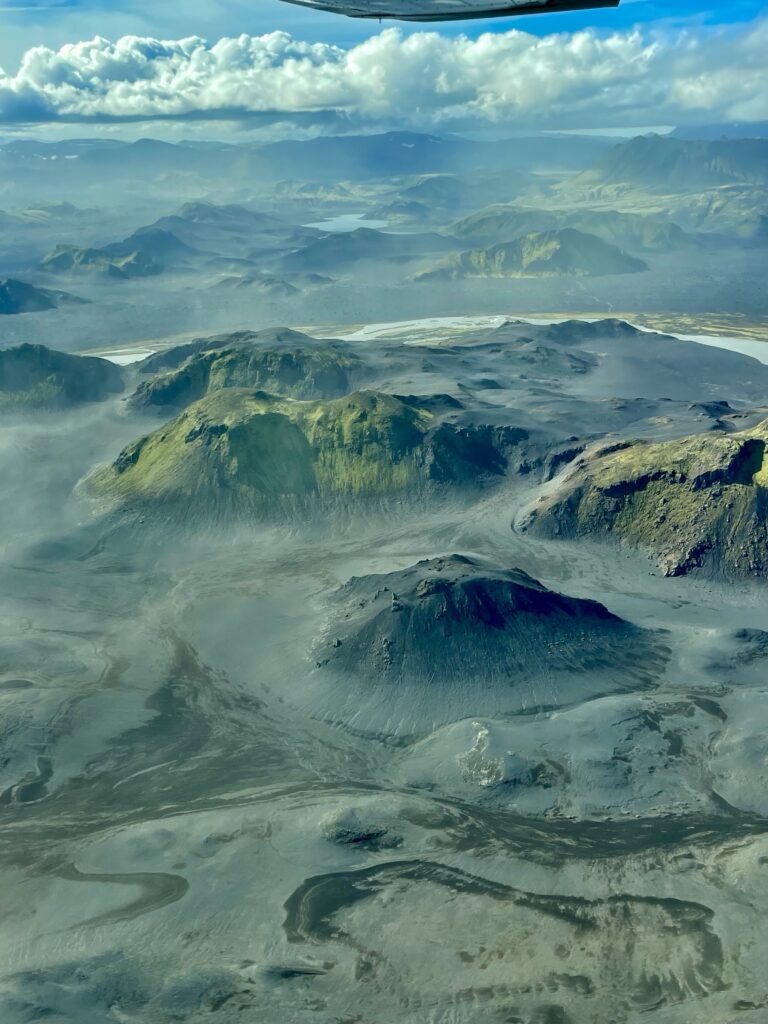
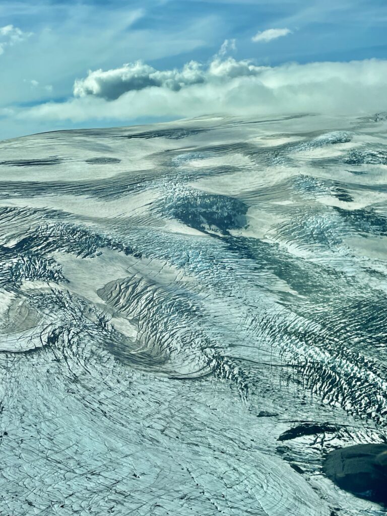
Then we took off against a blue and sunny sky. Through the headphones, Jon explained us where we were flying and explained what was what. From the sky, we saw, what you cannot see and comprehend when you are driving in the truck. The hills, mountains, valleys and plains, covered with green and grey moss, the many rivers and streams cutting through the landscape. It is so difficult to explain, that so much natural aggressive force of volcanic eruptions and earthquakes has created such a soft and peaceful landscape. It’s especially the ultra green moss which is covering the dark lifeless lava, that hides natures brutality in a magnificent way.

We flew over waterfalls, canyons, mountains an mountain ranges, volcanos, huge rivers turned deltas and even over one of the icecaps. Near the icecap in an area called Posmork, there was a gravel airstrip. After flying over twice, to check whether all was okay and whether the wind came from the right direction, Jon landed the plane on the strip. He parked the plane and took a picnic basket out of the luggage area. Right there, along the strip, in the middle of one of the most beautiful areas of Iceland (later, we would return to the area with the truck), we had a picnic, what a really unique experience! Another Cesna plane landed on the strip and parked behind us. A farmer with his family was on a Sunday Out to have lunch at the campsite and going for a hike near the airstrip.


After a coffee in the camp coffee shop, together with the farmer family, we went on a hike to the top of a hill, overlooking the airstrip, the camp and the larger river with glacier water, coming from the icecap. The area was really amazing. Down below, we saw cars struggling to get across the river, but most turned back due to high water and the risk of getting stuck in quick sand.


Back in the plane, we took off and flew to Westman Islands, not far from the coast of mainland Iceland. In 1973 the entire main island of 17km2 was evacuated, when the Eldfell volcano erupted. 1/5 of the only town on the island, Vestmannaeyjar, was destroyed by the lava flow. With help of the American army stationed in Iceland, big waterpumps were brought in to pump cold seawater and hose down the hot lava so it would solidify faster and stop flowing further in town. This helped saving the rest of the town.
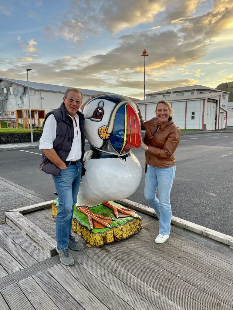
The island population came back and the island bounced back. The islanders are hard core fishermen who have a tendency to defy the authority of the government in Reykjavik. Fishing is still the main economic activity on the island, but the tourism sector is growing fast. The island has a large and accessible Puffin colony, which is the main point of attraction for tourists, who come over with the ferry. The main island is part of an archipelago, of which the main island is inhabited and the others are not (except for single hunting huts). Hunting on these islands, consist of catching birds and bird eggs on the cliffs. It’s the main area in Iceland (after the Westfjords) where this is still practiced. Young children start swinging on ropes from one side of a cliff to another on a small cliff on land at a young age, to prepare to continue the tradition.


Westman Island has a nice airport, however, it’s hardly used anymore, since the introduction of the ferry. After landing, you just walk over the apron and walk around the airport building. A taxi had to be called, since there are no taxis waiting at the airport anymore.

After a nice dinner in one of the cozy local restaurants, we did a little walk through the center of town before the taxi dropped us off again at the airport. With the sun starting to set over the horizon, we fly along the long black sand beach of Icelands south coast towards Reykjavik. Just before the night fell, we touched down on the runway of Reykjavik airport. After parking the plane back in the hangar, Jon brought us back to the campsite. We had the experience of a life time that day!


