After our last hike we drove towards the Georgian border. Did a last fill up of the fuel tanks (afterwards it turned out that diesel in Armenia was cheaper than in Georgia) and got ready for what I like so much, border-posts!
I had a bit of a fear that the customs in Armenia would come up with something to keep the truck in Armenia. (They are still very much under Russian influence and there is also a lot of corruption). I didn’t see any nice new European trucks in Armenia and almost every man in Armenia got excited when he saw our truck.
Since at the time we entered the customs were so difficult concerning our truck papers, we made some “adjustments” to have it look more official and we had the “registration” document laminated. Nothing illegal, but the fact remains that in Sint Maarten vehicle registration documentation is different from the way it’s done in most European countries.
Luckily our creativity worked out and we passed the Armenian border faster than when we came in!
Getting back into Georgia, was also much easier than the last time. (We probably were still in the system). We also still had our insurance in place from when we entered the first time, so that saved time as well.
We drove towards the city of Rustavi and not far from that city we drove up a steep hill on a bad road. A couple of big old buildings (just skeletons), where standing on the top. From here the view over Rustavi was amazing. We also had a bird eyes view on Georgias only race track and in the distance we could see the capital Tbilisi.


Driving down the hill the next day, we passed Rustavi and the race track. Left and right there is Georgia’s second hand car market. Thousands of used cars and trucks are for sale along the highway from Rustavi to Tbilisi.
Our next stop would be Tbilisi. Through I-Overlander we knew we could park on a big parking next to the beautiful modern city hall, but best would be to arrive on late Sunday afternoon, to be sure to have a (good) spot. The route into the city was easy and since it was Sunday, traffic was not bad.

We arrived at an almost empty parking lot in the early afternoon. Close to the end was a spot with a view on the river, which divides Tbilisi in two. So, it was Sunday, great weather, so a nice time to start our first city walk. Tbilisi is much bigger and more European than Yerevan. Many restaurants, wine bars and shops and……..a lot of European Union flags. Georgia is a candidate member and the majority of the population wants to be part of the EU and stay away from Russia. It’s already one of the big visible differences between Armenia and Georgia.


Nearby our parking lot, we crossed a main road and entered the old town where there is the entertainment. We found a large Carrefour supermarket nearby, with a large Georgian style food market on top. Many little restaurants, wine and cheese bars are clustered together in a large cozy hall (especially nice in winter timer). Walking further through the beautiful street with well preserved old buildings, we stopped at a small champagne bar. A very nice Georgian girl served us and provided us with a lot of useful information on what to see in Georgia.


There is a large daily flee market in the old town, were you can find a lot of antique and interesting used items (also from the Soviet times), as well as art and handicraft stuff. There is a nice atmosphere on the market and the sales people are totally not aggresive in trying to sell you something, they leave you alone.


From almost every restaurant or bar we passed, we heard live music, mostly piano. Musical instruments, especially pianos, were an important part of life during the Soviet times, especially with classical music. Today, that is still noticeable in Tbilisi. One piano player on a terrace of a restaurant played so beautiful, that we decided to have dinner there. A real Georgian restaurant, with Georgian specialities and some good Georgian wines. When visiting big cities, we skip our routine of dining in the camper and choose a good restaurant.

Walking back later that night, Tbilisi was still full of life. There is a large flower market open till late (flowers are important for Georgians. They are valuable gifts to loved ones and for decorating the graves).


Next morning we did a large walk through the city and also to parts of the “beaten tourist track”. Tbilisi is also transforming fast. Like what we saw in Baghdad, old monumental buildings with their typical wooden balconies (though often in bad shape) are torn down and replaced by modern apartment buildings. Due to its long history and being the capital of many different kingdoms and republics, Tbilisi has a very interesting architectural mix. Like what we have seen in so many countries, people are pulled to the large cities and apartment blocks growing like mushrooms in and around the cities, Georgia is no exception. In the rural areas there are less opportunities for employment and also healthcare and education is much better in the big cities.


A cable cart brought us to the top of the ridge, where you will find the big statute of “Mother Georgia” (like the one in Armenia), the ruins of an old fortress and a nice little bar with a small terrace overlooking the valley in which Tbilisi is situated.


What was a little disappointing during our walks, was the amount of graffiti all over town. A lot was related to Georgia becoming an EU member, but also a lot of protest graffiti against Russia. Especially in Tbilisi there is a strong youth movement (Tbilisi has large academic centers), who wants progress for the country and they do not see that happen by Georgia aligning itself with Russia. (In the rural areas you see or feel the opposite).


In one of the little streets away from the more touristic areas, you find some little local restaurants, often with only 2 or 3 tables. Menus are simple, but local and tasty. We settled down at one of them and with French music from the speakers, it felt like we were somewhere in Paris. While we were there we even saw a man running through the street, with his face cut half open and bleeding like a fountain! A little bar fight further down the road, and this reminded us, that Georgians like to drink a lot and get into heated arguments. Anyway, we had a good lunch!

Roaming the different areas of old Tbilisi we crossed the other side of the river as well. A large old factory complex has been turned into a backpackers paradise. A large hostel, with restaurants, bars and second hand clothing stores. Georgia is still a relatively cheap holiday destination and student intellectuals, like to visit places like Tbilisi to sniff up old socialistic, communistic and revolutionary ideas and impressions. But going a little bit away from that area, you fall back into streets of tourist focussed restaurants and bars, you find in so many other European cities.


We closed off the night at a restaurant owned and operated by Ukrainians. It was interesting to hear from the owner, how fast the city was changing. Prices for real estate are jumping fast, because of the influence of Arabs, Russians and Indians. Georgia received around 300.000 Russian “refugees” since the war in Ukraine. Which is a bit hard to understand, if you know, that the majority of the Georgians is very much in support of Ukraine. Georgia itself was invaded by Russia in 2008, to defend the Russian separatists of the breakaway region of Ossetia. Besides being a potential EU member, Georgia also has aspirations to become a NATO member (there already a NATO office in Tbilisi), much against the will of Russia.

Next day we did a very long walk in the direction on the large Tbilisi University. A beautiful area with large classical buildings, luxury hotels and a grand boulevard. The streets are filled with thousands of students. Nearby the university is an old wine factory, which used to stand in the middle of wide grapevines, before the suburbs of Tbilisi replaced them. The wine factory has been transformed into a culinary oasis with different restaurants, surrounded by century old trees, in the middle of old and new apartment buildings. We had an amazing lunch there together with some really good cocktails, a really lovely place!

Walking back towards to old town, we passed the famous Old Wall of Tbilisi (the remains of the old city wall, on which houses were built with large balconies. Nearby you also find Tbilisi’s version of the Tower of Pisa. (The Leaning Tower). A steel beam is holding to tower from faling over. Though not old (2011) and part of a puppet theatre, it became a tourist landmark. Nearby, in a small alley, we had our last dinner in Tbilisi. Tbilisi is really a nice city to visit. Lots to see, good restaurants and a welcoming atmosphere.


The Georgian Military Road was our next adventure. Leaving Tbilisi in the early morning, we drove towards the border with Russia. The Georgian Military Road is a famous road. Not only for its spectacular sceneries, but also the history of the road itself is interesting. It’s also the only road connecting Georgia with Russia. The road goes through the narrow Darjal Pass, which was the gateway for invading forces into Georgia. It’s actually the only pass through the mighty Caucasus mountain range. Though the centuries, this road has been extremely important for all empires who ruled on either side of the Caucasus. Just before the GMR starts, there is a beautiful monastery, not far from Tbilisi with a great view over a small town located at the junction of 2 rivers. Because of its proximity to the capital, its also a very popular tourist destination, hence it was busy. It’s one of these sites, where parts are fenced of a lot of signs of what you can and can not see or touch (because you have a lot of simple stupid tourists). Something we are not used to and therefore we were quickly in and out. The only hold up was an Indian guy who felt that he was a movie star and asked us to make many pictures for him. Not far from the monastery we found a a small spot where we stopped for a coffee break. It has a nice view on a small lake and while having our coffee, a monk of the another monastery (not publicly accessible) passed by on foot. I offered him coffee, but he preferred a glass of vodka. I forgot we were in Georgia!


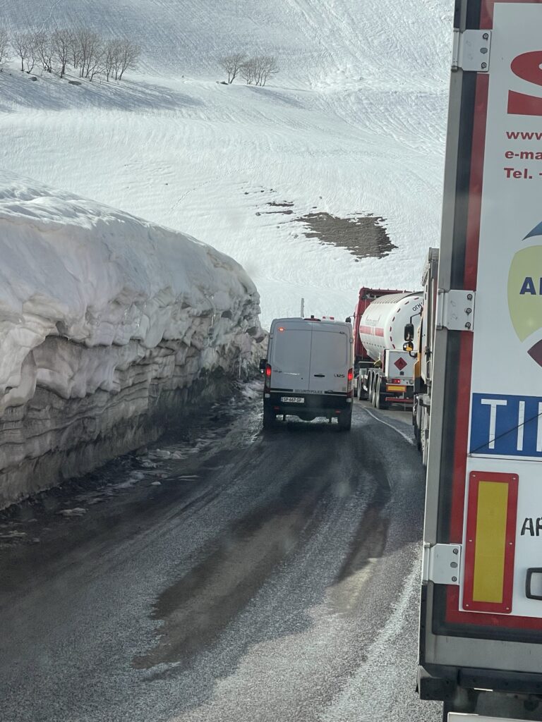
Since it’s the only land connection between Georgia and Russia, also all the cargo traffic has to use that road. The road is narrow and at many parts in bad shape. Steep and deep ravines are only separated by small, unmaintained barriers. The road even passes through a major ski resort area (Gudauri), which – with all the cargo trucks – does not have the charme you would expect from a ski-resort area. The higher we got, the layers of snow got thicker. All the time we drove behind trucks while being overtaken by kamikaze regular car drivers, even on corners, where you can’t see the traffic coming from the opposite direction.


At a certain point traffic stops, or actually the trucks stop. They are still being overtaken by regular cars. I decided to do the same, assuming that cargo trucks had to do something with either a weight bridge or Customs. I passed a very long line of waiting trucks, some were honking their horns, probably displeased with my action. At the end of the line, there was a police car. I stopped and asked if it was okay for me to continue on the road and it was indeed no problem.

With no truck traffic in front of us, we made some progress up the mountain (still being overtaken by other cars though), until we reached another line of trucks and cars. This time we couldn’t overtake, since there was more traffic coming from the opposite direction.
After more than an hour, our line started to move slowly. We still had no idea what the reason for the delay was. I was just thinking of all these truck drivers who have to drive this route on a frequent basis and have to waste their time waiting for hours.
Finally we saw what the reason for the hold up was, a tunnel. It’s a round tunnel, in which the trucks have to drive in the middle, in order not to hit the ceiling, which means you can only drive in one direction. The surface of the road inside the tunnel is also very bad, so you have the drive dead slow. This means that every couple of hours one direction is allowed to drive (however, some regular cars still drive in through the opposite way and causing extra delays. At the end it was not just one but five tunnels! With our almost 4mtr high unit which also moves a lot on the bad road due to its sub-frame, I was really afraid that I would hit the tunnel ceilings, but luckily it went all good.


Between 400 to 800 trucks pass each day, and it is in fact not the tunnels, but the Russian Customs who are the delaying factor at the end, since they are not increasing the capacity. Truck drivers can be stuck for days (and have to wait at allocated locations) before they can continue. In the wintertime, it can even be worse, due to heavy snow and land and mud slides. It’s hard to understand that in today’s modern world, these things are still occurring (but thats maybe because I look at it from a western perspective).
After the last tunnel we drove another few kilometers until we reached the town of Stepantsminda. Only there we actually discovered on of the reasons for the delays, the one way traffic measure. A long line of vehicles was waiting behind a police car, waiting until it was their turn to move on. A bit further, we saw an even longer line of trucks, waiting for the same. We could continue until the Russian border and drive back. Have experienced the way up, we didn’t want to go in the waiting mode again and decided to turn around a go in line with the passenger cars. After about an hour, the line was moving and we were on our way back. Driving down the mountain road we passed through the scary tunnels again and since our plan to camp near the Russian border, didn’t work out – and the day came to an end – we had to search for another camp spot, which we found near a river. It’s interesting to note, that a large Chinese construction company is making a multi-million dollar new road through the mountains (with tunnels) by-passing all the narrow hair-pins and small tunnels. The tunnel is partly financed by the European Development Bank and benefits mainly Russia. So it’s strange to see that Georgia is facilitating the construction of this new road (which they have to pay back to the banks) for Russia, a country they consider an enemy (they where ar war in 2008) and Europa is helping to finance this road, while the EU has put a lot of sanctions in place due to the war between Russia and Iran. The new road will be used to by-pass the sanctions, by obtaining the sanctioned goods from and via Iran.


Staying in the mountain area, we traveled along the northern road through the Georgian Caucasus. High in the mountains in a corner where Russia “surrounds” Georgia there is a beautiful park (Tusheti National Park) one of the “best places you have never heard of”. The flora, fauna and sceneries are unique.
Again, we drove higher into the mountains, passing a beautiful road with hardly any traffic. A sign let us to the ruins of a small fortified 8th century town of Kvetera where a small church is the only building still in use, between all the ruins. Just before going up north east we passed a beautiful monastery/fortress called Alverdi, which is located in the oldest wine region in the world. The monks make their own wine called Alaverdi Monastery Cellar. Their wine cellars date back to the 10th century. (Would be interesting to know if they still have some bottles in there from that time).


Driving further we passed the last village, where some road works were down. A supervisor told us that the road is blocked further up, but we always want to see that with our one eyes.
The road we were going to drive to and/or through the Abano pass, is considered one of the most dangerous roads in the world. Where the road was wide in the beginning it became more narrow while we proceeded. Often the road was wide enough for one vehicle (and we are driving a big truck). On the right side the road had no barriers, so one wrong move and we would fall down hundreds of meters in the valley. On the left side we often had to deal with rock overhanging, lower than the truck itself. Which means I had to drive as far right as possible to the edge of the road. I am telling you, it was dead scary at times and I started to wonder, why I was doing this. The many memorials we saw along this road of people who died on this road by falling off the road, should have been enough warning, to stop and turn back.


But driving to places were not many people go on hard to drive roads is addictive. Some jump with parachutes, this is ours (or at least mine) fetish. At one spot I had to really touch the rocks with the unit (and getting some scratches) to stay as far from to point of falling off, as possible. Marja stepped out of the truck, to make photos and video (but the real reason was, that if it would go wrong, at least one would be still around).
We drove until we reached a big landslide after we took several very sharp hairpin bends. We stepped out and walked a few hundred meters, and saw many more landslides. This was definitely as far as we could go. Now we had to turn back, but turn around was not possible. Driving back slowly on a steep incline and taking the hairpin bends driving backwards was not easy. The truck is not made for driving backwards on a steep incline and over loose stones. There is too much weight on the back, which means, by too much speed and breaking, it starts to slide.


Luckily we made it to a point on the road, where there was a power cable mast with some space around it. Here I could turn around the car and since it was pretty flat, we decided to stay there and camp for the night. Even though we didn’t reach the National Park, our surroundings were amazing, high steep mountains, covered with lush green forests, thousands of whistling birds and at night howling jackhals. And nobody around us!


The next morning we made a hike higher up the road, climbing over different mounts of debris from the many land and mud slides. We now really understood, that continuing this road was impossible. (We heard later that the road, going through the Abano pass will only be open somewhere in June. As long as there is snow, which melts, there will be landslides, so the road won’t be cleared after almost all the snow is gone).

Our last stop was a large waterfall which disburses its water over the road (quite spectacular). But what made an even bigger impression on us, was the memorial of a family of 7, who drove off the road with their big Russian Kamaz truck, into the dept of the ravine. None of them survived! If the road was good, without the blockage of the landslides, the remaining 40km’s would have been more challenging for us and maybe even deadly!


We did our portion of this deadly road and after the hike and a nice coffee break, we drove back to the main road. Now we were focused on the next far away corner of Georgia, this time the three country corner of Georgia, Russia and Azerbaijan. On the way we passed Gremi (once the flourishing capital of the Kingdom of Kakheti on the old Silk Road), on old ruined town, with a partly left castle and a church. After parking the truck, we walked towards these buildings, but on our way we passed a museum, which we actually wanted to skip. However, a big firm lady was waiting for us, outside the museum (she saw us parking the truck) and with some authority, she demanded us to get into the museum and buy tickets. So I thought, okay, she just wanted us to buy tickets, to visit the castle and the church. Out of respect, we did a quick tour through the museum, which by hindsight was quiet interesting. Gremi was once an important city in the 17th century. It was razed to the ground (together with many other cities, villages and farms in the region) by an invading moslim army, that killed every one and everybody, including life stock and also destroyed all vine-yards as the moslims didn’t want the Georgian christians at the time to ever produce wine again!


After visiting the museum, we visited the beautiful decorated church (still in use) and next to it is part of the old palace (called the bell tower). This was a separate museum, so we had to pay for a ticket again. A pretty drunk elderly guide, tried to sell his services to us, but his English in a drunk version, was hard to follow, so we passed the offer. (Drinking is bit of an issue in Georgia. There are almost more signs with “wine route” than traffic signs….that says a lot).
After this quick stop, we continued our trip towards the three corner area, where the oldest national park of Georgia is located. (Lagodekhi Nature Reserve). The road towards the park is also a road towards a border post.

Arriving at the park (you have to drive through some small streets in the town of Lagodekhi), a park ranger came directly to us. The park is not accessible by cars (let alone trucks), only for a few hundred meters). The ranger – a super nice and friendly guy – spoke very good English (lived in London for a few years), directed us to a nearby parking area. He then started to explain everything about the park, the history, rules, hiking tracks and the amenities. The park was founded in 1912 by the Tsar of Russia after strong advocacy by a former Polish army officer, Ludwik Mlokosiewicz, who saw the value of this natural area, which has such a rich biodiversity.
The next day was a rainy day and we decided to stay for the day and do a long hike in the park. The night before a small, older dog decided (probably because of the rain) to use the truck as her night shelter. The moment we left the truck for the hike, the dog started following us. It was the first time that we had a full day of rain and the first time we had to use our rain jackets since we left Europe.


The trail of the hike is well marked and it’s not allowed to leave the trail. First of all because of the fragile nature and secondly the park is part of the border area with Russia and Azerbaijan. (You are obligated to carry your ID or passport with you). But looking at the terrain, you wouldn’t even try to deviate from the track, the track is on a very steep mountain range covered with thick vegetation.

Despite her size and age, the dog stayed with us and really gave it all to do the complete hike with us. We walked for over two hours until we reached a big waterfall. That was also the end of the trail. From here we returned, still followed by the little dog. Even a scary bridge with metal grid plates, didn’t stop the dog from following us.

A little soaked by the rain we arrived at the truck. I first treated the dog on some water and food, before she went back under the truck again to rest. For us, it was time to take a shower, put on some dry cloths and drink a good hot coffee.

From the Lagodekhi park, we drove through the wine area of Georgia towards the next park. (Vashlovani Nature Reserve). The wine area consists mostly of small and medium size wineries ands wine cellars. It looks like a very fragmented industry in Georgia. Since it was still early in the season, there was not much to see besides little sticks with empty grapevines.
In the small town of Dedopolis Tskaro, we visited the park office, to obtain entrance tickets and to register for the border police (also this park is in the border area). The only thing was, that due to the size of the truck, we did not get a permit to drive through the park (didn’t understand why they still sold us the tickets and camp spots anyway).
From Dedopolis Tskaro we drove on the main road going south towards the park. The road is on a mountain ridge and goes through village after village. The villages, like so many of the villages we pass, consist 99% of older homes, and these are often abandoned. A paint job should do miracles on these old houses.
The signage to the park is almost non-existing or wrong. From a tar road, we followed a sign indicating “Vashlovani National Park”. It directed us on a once tarred road which was now like the surface of the moon with many, many potholes. The road took us about two hours to drive at 20km/hr). Sometimes there was a track next to the road, but what we fined out, was that the land left and right was thick, sticky and slippery black mud. For miles and miles, left and right the land was covered with fresh young sprouts of grain. The slippery mud didn’t help us to make speed, since you could loose control over the vehicle pretty fast and it could flip the truck.

After a long exhausting trip over the pothole road, we reached a remote village, with lots of empty houses and some apartment buildings. Big pigs were roaming the streets and big bulky musculair women where herding the cows. A group of rusty old farm machines were parked sadly next to each other. This was one of these farm communities, once set up by the Soviet planners. A dedicated community for farming wheats. Wheats are still farmed, but now harvested in a more efficient way and the workers don’t have to live in isolated villages like this anymore.


The roads through the villages were very muddy and with the empty houses the farm animals and the women, you wouldn’t say this country will soon be part of the EU.
Continuing the “road” through the villages, the road was now a dirt road only consisting of wet, very slippery mud. When you drive on a hill in an angle (not up but along), it’s easy to slide down, especially where the truck is the heaviest, the back. Of course this happens and the art is to keep driving (faster) and to keep the front of the truck on the track. So you are actually driving sideways. By doing so, you avoid that the entire truck goes down the hill.
Remnants of the old irrigation system (large concrete channels) are visible everywhere, like the huge empty delipitated warehouses and farm houses. In between there are large savanna style flats, with the wheats growing towards the surrounding hills. In the hills it’s then where you find the shepherds with their herds of sheep. And so, all the land has come to use, but where is the National Park? We drove to where the mountains came closer and the wheats stopped. These were areas of raw grassland, where sheep were grazing.
According to our Google Map and the digital map from the park office we were now at the main entrance of the park. We had to cross a dry river bed, but the steep banks were on-even and very muddy. Sliding down (sidewards) was possible and coming back, would almost be impossible, because of the steepness and the slippery mud. We looked around for other options, (a bridge was partly washed a way by a flush flood) but came to the conclusion, that this was actually the only way to get in. It’s actually a valley where you follow a river along a beautiful steep canyon, which is the highlight of the park. But for us, at this time, it was not accessible.

We drove back to the main road, this time following a mud track through the wheat fields in stead of the pothole road. Somewhere in the middle of these fields on an even smaller (dead end) track, we stopped and parked for the night. The view from here, reminded us of the African savannas. It was very beautiful.


In the early morning a shepherd woke us up, asking us if all was okay. It was probably a very unusual sight for him to see a big army style truck parked in the middle of the wheat fields.
Staying on the same track we continued towards the main tar road where we had another option to reach part of the park, Shavi Mountain. Also here the tar road suddenly changed into a mud track. It turned out to be a long track on a long ridge, which became at points very narrow. I now understood why the park office didn’t give us a permit for the truck to drive into the park.

It started to rain and it became very foggy. So with little visibility and driving on a muddy road, I decided to stop driving and park the truck on top of a hill. Around us we heard the voices of different shepherds, shouting commands to their sheep and cattle. They all have their own herds and tour the same route every day, keeping a distance from each other, to not mix up their herds. The lands (also in the park) are used as pastoral ground, nobody owns it, accept for the state and due to its vegetation and the climate its not suitable for other agricultural activities.

The fog was gone and the rain had stopped the next morning. We continued driving over the ridge and it did not get easier. Also here I hoped I would not encounter any opposite traffic, because there was no place to pass and even driving back was tough in the mud. Passing the sign “protective zone”, we were now for sure in the park, but stil we saw shepherds with their sheep in the park. Along the ridge we saw beautiful plants with nice flowers, which we had never seen before and were endemic for the region.


Finally we reached the ranger station, where nearby was also the official campsite. The ranger came to us, thinking and asking if we were Russian. When he realized we were not, he became grumpy either because we were no Russian (he made have been a fan of Russia), or maybe because we did not speak Russian (the second language in Georgia). He turned around and went back into his office. He didn’t ask for tickets or permits (he could have sent us back right away, since we had no permit to drive the truck in the park).
To continue the road to the camp site was impossible, since the tire tracks were so deep carved out in a hill (and angled over 45 degrees), that the truck for sure would get stuck. We only found out after driving in. (The ranger didn’t even mention that, he had just pointed out to us that we could continue driving). Besides there were a lot of low hanging tree branches, which resulted in a number of extra scratches on the truck.

I backed up the truck and parked it near the ranger station. We continued by feet about five kilometers towards the far end of the track and a small foot track through the forest. There at the end, was a big cross on a hill, Shavi Mountain. From here there was a beautiful view towards Azerbaijan, the part of the park which we could not reach the day before and in the back the stunning Caucasus mountain range (which is the Russian state of Dagastan). The cross is placed on the ruins of an old church. It’s a bit of a hassle to get to there, but it is one of these beautiful spots you will never forget.


